Understanding how to use historic maps and documentary evidence is fundamental to resolving boundary disputes in England and Wales. My Boundary Dispute Surveyors spend significant time researching historic Ordnance Survey maps, old conveyance documents, and archived property records when investigating boundary questions for clients. While modern GPS technology and laser scanning provide precise measurements of features as they exist today, historic boundary evidence reveals where boundaries were originally intended to lie and how they've been understood over decades or centuries. This guide explains the types of historic evidence available, where to find it, how professional boundary surveyors interpret it, and how historic maps can prove decisive in resolving disputes when modern title plans and physical features don't provide clear answers.
Why Historic Evidence Matters for Boundary Disputes
Modern Land Registry title plans operate under the general boundaries rule, showing only approximate boundary positions. When disputes arise about exactly where a boundary lies, historic evidence often provides the answer. Historic maps and documents matter for several crucial reasons including revealing the original intent when properties were first divided or sold, showing how boundaries have been consistently understood and depicted over time, providing more detailed boundary descriptions than modern simplified title plans, establishing that boundary features like walls or hedges have marked the same line for decades or centuries, and corroborating or contradicting current physical evidence about boundary positions.
In many boundary dispute cases we've worked on, historic evidence has been the deciding factor. For example, if a fence doesn't quite match the red line on the title plan, historic Ordnance Survey maps showing that same fence position since 1880 provide powerful evidence that the fence correctly marks the boundary and the modern title plan is simply imprecise.
The Weight Courts Give Historic Evidence
When boundary disputes reach court, judges give significant weight to consistent historic evidence. A boundary position shown consistently on maps from 1850, 1900, 1950, and 2000 is far more likely to represent the true legal boundary than a recently erected fence or a measurement from a modern title plan. Courts particularly value historic evidence that is consistent across multiple independent sources, predates the current dispute by many decades, comes from authoritative sources like Ordnance Survey, and aligns with physical features that still exist today. Understanding what historic evidence is available and how to interpret it is essential for anyone involved in a serious boundary dispute.

Types of Historic Boundary Evidence
Professional boundary surveyors research multiple types of historic documentary evidence when investigating boundary positions.
Ordnance Survey Historic Maps
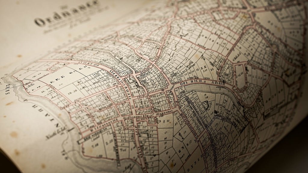
Ordnance Survey has mapped Britain at various scales since the early nineteenth century, creating the most comprehensive historic mapping resource available. Key Ordnance Survey map series include County Series maps from circa 1805 to 1940 at scales including 1:2500 (25 inches to the mile) for most of England and Wales and 1:10560 (six inches to the mile) for less developed areas, National Grid maps from 1940s onward at 1:2500 and 1:1250 scales, and modern digital mapping continuously updated. The County Series 1:2500 maps are particularly valuable for boundary research because they show remarkable detail including individual buildings, walls, fences, hedges, field boundaries, footpaths and tracks, trees and vegetation, and even boundary markers in some cases. These maps were surveyed over many decades with different areas updated at different times, meaning you can often find editions from multiple dates showing how boundaries changed or remained stable over time.
Title Deeds and Conveyance Documents
Historic property deeds often contain much more detailed boundary information than modern Land Registry documents. Old conveyances (the documents that transferred property ownership before Land Registry registration became compulsory) typically included written descriptions of boundaries like "from the oak tree along the center line of the hedge to the stone marker," measurements giving dimensions of the property, plans attached to the deed showing boundary positions in detail, and specific notes about boundary features, maintenance responsibilities, or boundary agreements. For properties with pre-registration title deeds, these documents can be invaluable. The challenge is that many old deeds were destroyed or lost when properties were first registered with Land Registry, as owners often submitted original deeds which weren't always returned.
Estate and Sale Plans
Historic estate plans showing how large land holdings were divided into individual properties, auction sale particulars with detailed plans of properties being sold, and development plans for new housing estates being laid out, all provide detailed boundary information from specific dates. These plans were often drawn to larger scales than Ordnance Survey maps, showing boundary details more clearly.
Tithe Maps and Apportionments
Tithe maps created between 1836 and 1852 show land ownership and occupation for the purpose of commuting tithes (payments to the church) to cash payments. While drawn at relatively small scales (typically 1:3960 or about 13 inches to the mile), tithe maps show field boundaries, property divisions, and land ownership patterns from the mid-nineteenth century. The accompanying tithe apportionment documents list landowners and occupiers, providing names that can be traced through other records.
Enclosure Maps
Enclosure maps created from the mid-eighteenth to mid-nineteenth centuries show how common land was divided into private ownership. These maps often show newly created boundaries with great precision, as the whole point of enclosure was to define exactly what land each person received. For rural properties whose boundaries date from enclosure periods, these maps can be definitive evidence of original boundary positions.
Early Ordnance Survey Draft Plans
The original surveyors' draft drawings for Ordnance Survey maps (many held in archives) sometimes show more detail than the published maps, including field names, property owner information, and specific boundary features. These drafts can reveal information not visible on published maps.
Where to Find Historic Boundary Evidence
Accessing historic maps and documents requires knowing where to look and how to search various archives and collections.
National Library of Scotland
The National Library of Scotland website provides free online access to historic Ordnance Survey maps for the whole of Great Britain, with a wonderful interface allowing you to view maps from different periods side by side, zoom in to see fine detail, overlay modern maps on historic maps to compare, and download high-resolution images. This is the first resource any boundary surveyor turns to when researching historic boundary positions. The site includes maps from the 1840s through to modern mapping, allowing you to trace how boundaries have been depicted over more than 150 years.
Land Registry
HM Land Registry holds filed plans referenced in title registers, historic edition title plans showing how a property's registered extent has changed over time, and copies of conveyance documents that were submitted when properties were first registered. You can order these documents from Land Registry for a small fee (typically three to seven pounds per document). For researching boundary history, requesting previous edition title plans can show whether the boundary position has changed since first registration.
Local Record Offices
County and local record offices hold tithe maps and apportionments, enclosure maps and awards, estate plans and surveys, sale particulars and auction catalogues, and historic photographs including aerial photographs showing boundaries. Access policies vary but most record offices allow free research visits though copying documents may incur charges. Staff can help locate relevant documents if you know your property's historic parish and approximate dates of interest.
The National Archives
The National Archives at Kew holds valuation office maps from 1910 to 1915 created for the Finance Act 1910 (sometimes called "Lloyd George's Domesday"), early Ordnance Survey records including original surveyors' drawings, some historic estate and property records, and various other documents that may contain boundary information. Accessing these records requires visiting Kew or paying for document retrieval services.
Private Collections and Sellers
Old property deeds may still be held by the current property owner or their solicitor if the property was registered with Land Registry relatively recently. Previous owners may have retained copies of deeds or historic plans when they sold. Local history societies sometimes maintain collections of historic maps and documents. Asking neighbors who have lived in an area for many years can reveal information about historic boundary positions and changes.

How to Interpret Historic Maps
Finding historic maps is one thing; interpreting them correctly requires understanding their limitations and how to extract useful boundary evidence.
Understanding Map Scales
Historic maps were drawn at various scales which determine how much detail they can show and how accurately they can be measured. The 1:2500 scale (25 inches to one mile or about 40 inches to one kilometer) shows remarkable detail with one millimeter on the map representing 2.5 meters on the ground. Boundary walls, hedges, and fences are visible, and measurements can be taken with reasonable accuracy. The 1:10560 scale (six inches to one mile) shows general boundary positions but fine detail is lost. These maps are useful for understanding overall property layout but not for precise boundary determination. The 1:63360 scale (one inch to one mile) shows only very general positions and is not useful for boundary disputes. When using historic maps for boundary evidence, boundary surveyors focus primarily on large-scale maps (1:2500 and larger) where boundary features are clearly depicted.
Map Accuracy and Limitations
Historic Ordnance Survey maps were surveyed to remarkably high standards for their time, but they still have limitations. Surveying methods including chain and compass surveying until the late nineteenth century, theodolite surveying for later editions, and plane table surveying for some areas, each had characteristic error patterns. Errors accumulate over distance so boundaries shown on opposite sides of a large property may be less accurate relative to each other than boundaries shown close together. Map drawing and printing processes in the nineteenth and early twentieth centuries introduced small distortions, particularly in paper maps which could stretch or shrink with humidity changes. Professional surveyors account for these limitations when using historic maps as evidence, typically treating map evidence as accurate to within one to two meters at 1:2500 scale.
Identifying Boundary Features on Maps
Ordnance Survey maps use specific symbols to show different types of boundary features. Learning to recognize these symbols helps extract maximum information from historic maps. Pecked lines show fences, solid lines of appropriate thickness show walls (with thicker lines for thicker walls), specific vegetation symbols show hedges, and dotted or broken lines show unclear or disputed boundaries. Comparing how a boundary is shown across multiple map editions reveals whether it's been consistently depicted the same way (suggesting a stable boundary) or has changed position or character over time.
Overlaying Historic Maps on Modern Surveys
Modern surveying technology allows us to georeference historic maps (mathematically transform them to match modern coordinate systems) and overlay them on current measured surveys. This process reveals how historic boundary positions relate to current features on the ground, shows whether physical boundaries have remained in the same positions over time, identifies discrepancies between historic understanding and current positions, and provides visual evidence that can be presented in reports or court proceedings. Specialist GIS software performs these overlays with accuracy, allowing measurements to be taken from georeferenced historic maps and compared directly with modern survey data.
Using Historic Documents Alongside Maps
While historic maps provide visual evidence of boundary positions, written documents provide context and detail that maps alone cannot.
Extracting Boundary Information from Deeds
Old conveyance deeds typically describe properties using a combination of written description starting from a known point and following the boundary around the property, measurements giving distances along each boundary section, references to physical features like "along the center of the stream" or "following the hedge," and references to adjoining owners whose identities can be traced through other records. A skilled boundary surveyor can use deed descriptions to plot likely boundary positions on modern plans, particularly when combined with surviving physical features mentioned in the deeds.
Interpreting Legal Language in Historic Deeds
Historic conveyances use specific legal terminology that has precise meanings. Understanding this language is crucial for correct interpretation. Terms like "hereditaments" means lands and buildings and all rights attached to them, "appurtenances" refers to rights belonging to the property like rights of way, "messuage" is an old term for a dwelling house with outbuildings and land, and boundary descriptions like "thence northwards" or "thence in an easterly direction" along described features. Professional advice from solicitors experienced in property law may be needed to interpret complex historic deeds correctly.
Tracing Property Ownership History
Understanding who owned and occupied properties historically can reveal information about boundaries. If you can establish that the same family owned both your property and your neighbor's property in the past, and then divided them by selling one off, finding the conveyance document for that sale should show exactly where the boundary was intended to be. Historic Land Registry records, census records, electoral registers, and rate books all help trace ownership and occupation history.
Common Patterns in Historic Boundary Evidence
After researching hundreds of boundary disputes, boundary surveyors recognize common patterns in how historic evidence relates to current disputes.
Stable Boundaries
The most straightforward cases involve boundaries that have remained stable for decades or centuries. If historic maps from 1850, 1900, 1950, and 2000 all show a wall or hedge in the same position, and that feature still exists today in the same place, this provides very strong evidence that the boundary lies along that feature. Even if the modern title plan doesn't quite match due to the general boundaries rule, the historic consistency strongly supports the physical feature's position.
Gradual Boundary Creep
Sometimes historic maps reveal that a boundary has gradually moved over time. Perhaps a fence shown in one position in 1880 appears slightly different in 1920 and has moved further by 1960. This "boundary creep" often results from fences being replaced slightly inside or outside their original positions each time, with small changes accumulating over generations. Historic evidence showing this pattern can explain current discrepancies and help establish where the boundary should properly be.
Lost Boundary Features
Historic maps sometimes show boundary features that no longer exist like a hedge that was grubbed out decades ago, walls that have been demolished, or streams that have been culverted or diverted. If the historic feature's position can be identified, it may reveal where the boundary should be even though the original marker is gone. This is where combining historic maps with modern measured surveys becomes powerful—we can establish the likely location of historic features using reference points that still exist.
Discrepancies Between Sources
Not all historic evidence is consistent. Different maps from similar dates may show boundaries slightly differently, deed descriptions may not quite match map evidence, and physical features may not align with documentary evidence. When discrepancies exist, boundary surveyors must evaluate which sources are most reliable for the specific property and boundary in question, considering factors like map scale and accuracy, whether the surveyors or deed makers would have actually visited the property, how close in time sources are to when the boundary was originally created, and consistency across multiple sources.

Presenting Historic Evidence in Boundary Disputes
Collecting historic evidence is valuable only if it can be presented effectively to resolve disputes.
Creating Clear Comparative Plans
Professional boundary survey reports include plans showing the relationship between historic and modern evidence. Effective plans overlay historic map evidence on modern surveys showing how boundary positions have or haven't changed, display multiple historic map editions side by side showing consistency or change over time, clearly mark discrepancies between different evidence sources, and use color coding and annotations to make complex evidence understandable. These visual presentations are far more effective than written descriptions alone, particularly when presenting evidence to neighbors, solicitors, or courts.
Documenting Research Methods
Professional boundary surveyors document their research process including listing all sources consulted (even if they didn't yield useful information), explaining how maps were georeferenced and overlaid, describing any calculations or measurements taken from historic maps, and noting limitations and uncertainties in the evidence. This transparency builds credibility and allows others to verify the work if needed.
Expert Opinion Based on Historic Evidence
Raw historic evidence must be interpreted to form opinions about boundary positions. Boundary surveyors acting as expert witnesses analyze all available historic evidence alongside modern surveys and title documents, weigh different sources according to their reliability and relevance, identify the most likely boundary position based on the totality of evidence, explain the reasoning supporting their opinion, and acknowledge areas of uncertainty or alternative interpretations. This expert analysis turns historic maps from interesting historical documents into powerful evidence for resolving boundary disputes.
Cost and Time for Historic Research
Property owners considering commissioning historic boundary research should understand the costs and timescales involved.
Typical Research Costs
Historic boundary research by professional land surveyors typically costs between one thousand and five thousand pounds depending on the property's location, how far back research needs to go, complexity of the property's history, availability of documents (some require expensive archive visits or document retrieval), and level of detail required for the final report. While this represents significant expenditure, it's far less than the cost of legal proceedings (typically twenty thousand to fifty thousand pounds or more to trial). If historic evidence can resolve a dispute without court action, research costs are money well spent.
Research Timescales
Allow two to six weeks for comprehensive historic boundary research depending on document availability and archive access requirements. Some documents can be accessed online immediately while others require visits to record offices or waiting for Land Registry to retrieve filed documents. Factor research time into your overall dispute resolution timeline.
Limitations of Historic Evidence
While powerful, historic maps and documents have limitations that must be acknowledged.
Not All Properties Have Good Historic Evidence
Some properties particularly modern developments on land that was never previously developed lack detailed historic evidence beyond recent decades. Areas that were open fields until recent development may have little historic mapping showing internal boundaries. In such cases, other evidence like title deeds and modern surveys become more important.
Historic Evidence Can Be Contradictory
Different historic sources sometimes contradict each other. When this happens, disputes may not be fully resolved by historic research alone, and negotiation or legal proceedings may still be necessary. However, even contradictory historic evidence helps frame the dispute and may narrow the range of reasonable boundary positions.
Not Definitive Without Court Determination
Unless a property has a determined boundary registered with Land Registry, historic evidence (like all boundary evidence) provides opinions about likely boundary positions but doesn't definitively establish legal boundaries. Only a court or Land Registry determination process can create legally binding boundary positions. Nevertheless, strong historic evidence often convinces neighbors to accept boundary positions without formal determination.
Conclusion
Historic maps and documentary evidence are invaluable tools for resolving boundary disputes in England and Wales. Ordnance Survey maps from the nineteenth and twentieth centuries, old conveyance deeds and property documents, estate plans and sale particulars, and tithe maps and enclosure awards all provide evidence about boundary positions that complements modern surveys and title plans. Professional boundary surveyors research these historic sources, interpret them correctly accounting for their limitations, overlay historic evidence on modern measured surveys, and present findings clearly in reports suitable for negotiation or court proceedings. While historic research represents additional cost and time, it frequently provides the decisive evidence needed to resolve disputes without expensive litigation.
At My Boundary Dispute Surveyors, historic research is a core part of our boundary investigation process. Our experienced land surveyors know where to find historic evidence, how to interpret nineteenth and twentieth century maps and documents, and how to present historic evidence effectively to resolve boundary disputes. Whether you're facing a dispute where modern evidence is unclear or simply want to understand your property's boundary history, we can help.
Need Historic Boundary Research?
Our experienced surveyors conduct comprehensive historic boundary research using Ordnance Survey maps, old deeds, and archived documents. We combine historic evidence with modern surveys to provide clear evidence for resolving boundary disputes professionally.
Frequently Asked Questions
How far back should historic research go for boundary disputes?
Ideally back to when the boundary was originally created whether through property subdivision, estate development, or enclosure. For most properties this means researching Ordnance Survey maps from the 1850s onward and any earlier documents that survive. The further back consistent evidence goes, the more persuasive it becomes.
Can I do historic boundary research myself?
You can access many resources like National Library of Scotland maps yourself. However, interpreting historic maps correctly, georeferencing them to modern surveys, accessing archived documents, and presenting findings as expert evidence typically requires professional surveyor expertise. Self-research can help inform your understanding but may not be sufficient for resolving disputes.
What if historic maps show my boundary differently from where it is now?
This suggests the boundary may have moved over time possibly through boundary creep, deliberate alteration, or errors. Historic evidence showing the original position can be powerful support for requiring boundaries to be corrected. However, very long-established physical boundaries may have acquired legal status through adverse possession, requiring careful legal analysis.
Are Ordnance Survey historic maps legally binding?
No, historic Ordnance Survey maps are evidence of how boundaries were depicted at specific dates but are not legally binding. Like modern title plans, they show general positions subject to the surveys' accuracy limitations. However, consistent depiction across multiple map editions provides strong evidence of where boundaries were understood to lie.
How much does it cost to get historic Land Registry documents?
Official copies of title registers and filed plans cost three pounds each for digital copies. Previous edition title plans showing historic registered extents cost seven pounds. Retrieval of old deeds filed at first registration (if they still exist) costs more depending on document retrieval costs. Budget two hundred to five hundred pounds for comprehensive Land Registry historic research.
What if no historic maps exist for my property?
Very few properties lack any historic mapping—Ordnance Survey mapped virtually all of England and Wales by the late nineteenth century. However, the level of detail varies. If large-scale maps don't exist, smaller scale maps and written documents like deeds become more important. Your boundary surveyor can advise what evidence is available for your specific property.